Mid Ulster Council Report 2026 - Major Projects and Active Travel
This page provides details specific to Mid-Ulster Council area for 2026.
Project Lifecycle
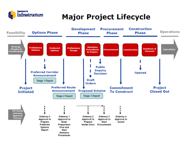
Strategic Road Improvements
Scheme Name 1 – A5 Western Transport Corridor (A5WTC)
TABLE 60: Scheme 1 details
| District Council area(s) | Derry City and Strabane; Fermanagh and Omagh; Mid-Ulster. |
|---|---|
| Location | New Buildings to border south of Aughnacloy |
| Scheme description | Provision of new off-line dual carriageway |
| Scheme length | 85 km |
| Scheme estimated cost | £2.1 bn |
| Scheme website | A5wtc.com |
| Any related schemes? | ROI Links - N14/N15 upgrade schemes at Lifford and N2 upgrade schemes south of the border in Monaghan. |
| Current stage | The A5 Western Transport Corridor (A5WTC) project remains at the statutory procedure stage. |
| Current position | Previously Authorised Section ( Section 2 and Section 3 Phase 1 B Sion Mills to Ballygawley) The Court of Appeal found in favour of the Department on all grounds on 6 October 2026. Any party to the litigation may still seek leave to appeal this decision. While the Department was successful, the legal position remains unchanged until the Court makes the formal order giving effect to its judgment. As the wording of that order may affect the next steps, the Department will await its receipt before taking any substantive action. However, in the background the Department is continuing to progress the work required to enable delivery of this important strategic route at the earliest opportunity. This will involve completing the remaining checks and approvals as well as getting agreement on costs with the current contractors. Section 1 (New Buildings to Sion Mills) Section 3 Phase 3 (Ballygawley to south of Aughnacloy) |
Scheme Name 2 - A29 Cookstown Bypass
TABLE 61: Scheme 2 details
| District Council area(s) | Mid-Ulster |
|---|---|
| Location | Cookstown |
| Scheme description | Provision of a new bypass to the east of Cookstown extending from the A0029 Dungannon Road to the A0029 Moneymore Road. The scheme includes for improvements the Sandholes Link Road from Drum Road to Sandholes Road. A footway/cycleway will be provided along its entire length connecting into the existing network. |
| Scheme length | 4 km |
| Scheme estimated cost | £100m |
| Scheme website | A29 Cookstown Bypass |
| Current stage | The draft Statutory Orders and Environmental Impact Assessment Report were published on 03 April 2024. Following the consultation period, it was agreed to hold a Public Inquiry on the scheme which commenced on 22 October 2024 and concluded on the 24 October 2024. The Inspector’s Report was received by the Department in February 2025, and the recommendations have been carefully reviewed. The Department held a Social Valve Engagement exercise in Autumn 2025 to seek the views of the community on the wider social value benefits they would like to see delivered as part of the A29 Cookstown Bypass scheme. The Outline Business Case for the scheme has been issued to the Department of Finance for approval in September 2026, with approval being aligned with the MSW Growth Deal signing in early 2027. |
| Current position | The Court's judgment on the A5 Appeal represents a significant milestone for the Department. Time will be taken to consider it in detail and its implications for the major projects to be taken forward by the Department, however, the judgment provides important legal clarity and vindicates the Department’s position throughout that it complied with the requirements of the Climate Change Act. The positive judgment on the A5 appeal would permit my officials to proceed with the making of the relevant Statutory Orders. The timescales for progressing to procurement and construction will depend on several factors including, the completion of statutory procedures and the availability of funding in future years. |
Active Travel
Completed Works 2025 – 2026
TABLE 70.1: Pedestrian Measures completed
| Number of sites | Total cost |
|---|---|
| 1 | £100,000 |
| Road Number | Road Name | Scheme Description | Status |
|---|---|---|---|
| A0045 | Ballynakilly Road, Coalisland at Creenagh Bridge | Footway provision (in conjunction with a Carriageway realignment and Bridge Replacement scheme) | Complete |
TABLE 70.2: Cycling Measures completed
| Number of sites | Total cost |
|---|---|
| 3 | £592,000 |
| Road Number | Road Name | Scheme Description | Status |
|---|---|---|---|
| A0029 | Dungannon Road, Cookstown | Footway/Cycleway provision (Phase 2) from Riverdale Drive towards Killycolp Road | Complete |
B0040 B0161 | Moneymore Road & Ballyronan Road, Magherafelt | Cycleway provision from Moneymore Road to Ballyronan Road & Meadowbank Road – Route Appraisal and Preliminary Design | Ongoing |
| U5147 | Killyfaddy Road, Magherafelt | Footway/Cycleway provision – Design and Lands Acquisition | Ongoing |
Planned Works 2026 – 2027
TABLE 71.1: Pedestrian Measures planned
| Number of sites | Total cost |
|---|---|
| N/A | N/A |
| Road Number | Road Name | Scheme Description | Status |
|---|---|---|---|
| N/A |
TABLE 71.2: Cycling Measures planned
| Number of sites | Total cost |
|---|---|
| 10 | £165,000 |
| Road Number | Road Name | Scheme Description | Status |
|---|---|---|---|
| A0042 | Gulladuff Road, Gulladuff | Footway/Cycleway provision from Gulladuff Village towards Maghera – Lands Acquisition | Ongoing |
| A0045 | Granville Road, Dungannon | Footway/Cycleway provision (Phase 2) from Granville Industrial Estate towards Killybracken Road – Lands Acquisition | Ongoing |
| B0034 | Killycolp Road, Cookstown | Footway/Cycleway provision from A29 Dungannon Road towards CAFRE Campus – Design and Lands Acquisition | Ongoing |
B0040 B0161 | Moneymore Road & Ballyronan Road, Magherafelt | Cycleway provision from Moneymore Road to Ballyronan Road & Meadowbank Road –Preliminary Design | Ongoing |
| B0043 | Mullaghmore Road, Dungannon | Footway/Cycleway provision from Castleview Heights towards Town Boundary – Lands Acquisition | Ongoing |
| B0161 | Mountjoy Road, Brockagh | Footway/Cycleway provision (in conjunction with a Network Development Carriageway Realignment scheme) – Lands Acquisition | Ongoing |
| B0182 | Deerpark Road, The Creagh | Footway/Cycleway provision from Hillhead Road towards Anahorish Primary School – Lands Acquisition | Ongoing |
| C0051 | Tirkane Road, Maghera | Footway provision at St Brigid’s Primary School / An Carn Centre – Lands Acquisition | Ongoing |
| U1027 | Gortgonis Road, Coalisland | Footway provision from Moor Road (west) towards Coalisland Canal and (east) towards Annaghmore Road – Route Appraisal and Preliminary Design | Planned |
| U5147 | Killyfaddy Road, Magherafelt | Footway/Cycleway provision – Design and Lands Acquisition | Ongoing |