Need for scheme

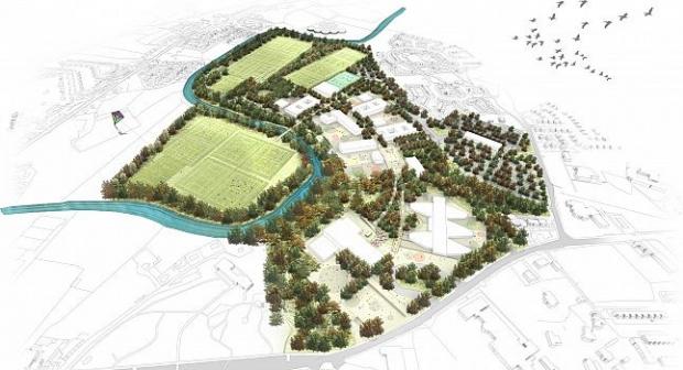
In recent years, the need for a link road has been given further impetus as a result of the Education Minister giving a commitment to fund the construction of the Lisanelly Shared Education Campus project in Omagh. The project makes provision for the construction of up to 6 schools within the grounds of the former Lisanelly military base adjacent to the B48 Gortin Road to the north of Omagh’s town centre.

The proposed scheme
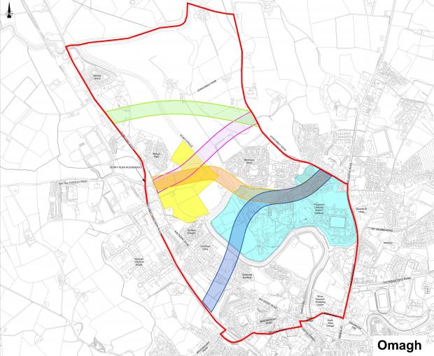
The proposed scheme is located on the approach to Omagh from Strabane, to the north-east of Omagh town. The scheme area extends from the A5 Great Northern Road to the west and to the Gortin Road to the east. To the south the scheme is bounded by a section of the B48 and Omagh’s town centre, while the north is defined by the River Strule.
The key objectives of the proposed Strathroy Link Road scheme are:
- to provide a Link Road from the western side of Omagh across the River Strule to facilitate improved access to the site of the proposed Lisanelly Shared Education Campus
- provide a link between the north-west of Omagh and the north-east of Omagh, and thereby reduce journey times between the two
- reduce traffic congestion in Omagh town centre
- increase the safety of road users in Omagh town centre by reducing traffic congestion and providing good Non-Motorised User connectivity from the west of the town to the Lisanelly Shared Educational Campus
- to minimise the impact on the natural and built environment
- assist in the economic development of Omagh and therefore produce an increased positive return on capital investment
Lisanelly Shared Education Campus
On 22 April 2009 at the inaugural Lisanelly Shared Educational Campus Steering Group meeting held in Arvalee School and Resource Centre, the Education Minister, Caitriona Ruane announced that funding had been allocated by the Department of Education and Strategic Investment Board Ltd to be used to develop exemplar designs and associated technical work for a Shared Educational Campus in Omagh.
More infromation on the progress of the scheme is available on the Lisanelly Shared Education Campus website.
Current position
An Environmental Statement was prepared in 2011 by consultants Amey in support of the Department’s planning application for the scheme. As an integral part of the planning process this was made available to consultees. Comments were received from a number of the statutory bodies and as a result an Environmental Statement Addendum was prepared and published in August 2012.
A notice was also published in local and regional newspapers and within the publication section of the Department's website highlighting the conclusions from the Department’s Report to Inform an Appropriate Assessment in accordance with the EC Habitats Directive, as transposed by the Conservation (Natural Habitats, etc) Regulations (Northern Ireland) 1995 as amended by the Conservation (Natural Habitats, etc.) (Amendment) Regulations (Northern Ireland) 2012 in Northern Ireland.
Gateway 1 approval was granted on the 18 August 2015 permitting the development of the Stage 3 Scheme Assessment Report (SAR 3) and the commencement of the Statutory Procedures.
The Notice of Intention to Make a Vesting Order (NIMVO) was published on the 11 November 2015.
Gateway 2 & 3 approval was granted on the 27 June 2016 to permit the development of the contract documents and the commencement of the procurement process.
The Pre-Qualification Questionnaires (PQQs) were advertised on the eTendersNI Portal in August 2017 and subsequently assessed in September 2017.
Approval to issue the tender documents and make the Vesting Order was granted on the 16 November 2016.
Tender documents were issued on the 21 December 2016.
Notice of the Making of the Vesting Order (NMVO) was published on the 8 February 2017 and the Vesting Order became operative on the 13 March 2017.
The contract for the works was awarded to Fox Contracts of Carrickmore on the 2 June 2017.
Works commenced in September 2017 on the Derry Road side of the River Strule. The replacement of Hunters Crescent Floodwall which is included within the contract is programmed for completion before the end of the 2017 calendar year. The construction phase is scheduled to take 66 weeks to complete.
Links to published documents are provided below for information.
Scheme documents
- Strathroy Link Road - Stage 1 Scheme assessment report
- Strathroy Link Road - Stage 2 Scheme assessment report
- Strathroy Link Road - Environmental statement
- Strathroy Link Road - policy impact assessments
- Strathroy Link Road – Notice of Habitats Directive appropriate assessment
- Strathroy Link Road – Report to inform an appropriate assessment
- Strathroy Link Road - Notice of making a Vesting order
- Strathroy Link Road - Contract Award Notice
Updated 14 September 2017
