Lightweight polystyrene was installed either side of the River Curly bridge to reduce embankment loads on the approach to the bridge. Top down construction was employed to simplify the construction of the Dowland Road bridge. No permanent works took place in the River Roe or the River Curly in recognition of their importance as fishing waters.
Careful construction practice protected the historic Doctor’s Belt trees from damage and the planting of over 7,000 new trees significantly enhanced the area.
Contract details
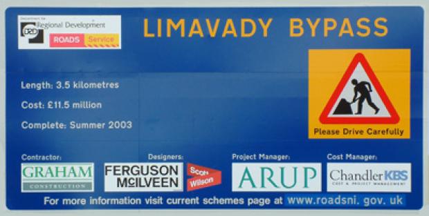
| Length: | 3.5 kilometres |
|---|---|
| Type: | Single carriageway |
| Contract: | Design and build |
| Contractor: | Graham Contracts |
| Status: | Open to traffic on 4 July 2003 |
Description of the bypass
The bypass:
- diverges from Ballykelly Road west of the town
- runs in shallow cutting to Seacoast Road roundabout
- continues on embankment to cross over the River Roe
- continues north east on low embankment and then cutting to Killane roundabout.
- turns south east in cutting, crossing beneath Dowland Road and through the western perimeter of the Drenagh Estate
- rejoins Broad Road south east of Rathmore Road
Links to the local road network include:
- a priority junction connecting the bypass to Farlow Road and Ballykelly Road East
- Seacoast Road roundabout connecting the bypass to Seacoast Road North and South
- a priority junction located midway between the Seacoast Road roundabout and Killane roundabout connecting the bypass via Town Link to Main Street and Ballyclose Street
- a priority junction connecting the bypass (Drenagh Link) to Rathmore Road
- Killane Link constructed on embankment connecting to Killane roundabout and Windyhill roundabout.
- Windyhill roundabout connecting to Dowland Road North and South and to Windyhill Road
The bypass includes three bridges:
- 40 metres span bridge carrying the bypass over the River Roe
- 25 metres span bridge carrying the Killane Link over the River Curly
- 32 metres span bridge carrying Dowland Road over the bypass
Key dates
|
1960s |
Motorway network to extend into the northwest of the province. Motorway would have skirted around the north of Limavady with access to the town via a grade separated interchange. |
|---|---|
|
1970s |
Motorway proposal scaled down to a trunk road bypass starting at Gortcorbies east of the town and continuing west bypassing Ballykelly before rejoining the existing road west of Greysteel. |
|
1980s |
Bypass north of Roe and Western Relief Road examined; this would have diverted from the existing road at Shanreagh Crossroads, crossed over the Roe on a new bridge and connected to the western end of Main Street. |
|
1991 |
Current alignment adopted in the Limavady Area Plan 1984 - 1999, Alteration No 1. Included the '+35 metre low level alignment' through the Drenagh Estate, thus avoiding damage to the Doctors Belt trees at Scriggan Road. |
|
1994 |
Publication of Direction Order and Environmental Statement. |
|
2001 |
Compulsory purchase of lands to build the bypass. Doctor's Belt Trees purchased by agreement. |
|
December |
Contractor appointed and construction work starts. |
| July 2003 |
Bypass complete and open to traffic. |
Key features
|
Environment |
Roads Service has acquired the Doctor's Belt trees at Scriggan Road to protect this important environmental asset for posterity. Careful construction practice will protect the trees from damage and new planting will enhance the area. |
|---|---|
|
Archaeology |
Historical records show that O'Cahan's Castle (a tower house) existed somewhere near the Castle River and that the original settlement of Newtown Limavady may have existed on the Roe floodplain. An archaeologist will watch whilst topsoil is being removed and will take appropriate measures to record, remove or protect substantial finds. |
|
Ecology |
Careful construction practice will protect the Roe and Curly from any harmful effects. Measures have also been included to protect the badgers and bats whose presence have been identified close to the site. |
|
Ground Engineering |
Innovative design solutions will overcome the difficulties of building road embankments over the soft alluvial clays in the Roe and Curly floodplains. |
|
Roe & Curley Bridges |
Integral bridge construction techniques will simplify and reduce the cost of constructing these bridges. |
|
Dowland Road Bridge |
Top down construction techniques will simplify the construction of this bridge, reducing traffic management and ensuring uninterrupted traffic access to the important Aghanloo Industrial Estate. |
Updated 6 August 2015
